
Downloads
GPS
There are plenty of different GPS formats available, and very little compatibility between them. A good starting point is the KMZ file for Google Earth, or the GPS Exchange format (GPX) file which is accepted by several formats, including several iPhone apps.
The Point of Interest data for the Exe Estuary and approaches has been converted using GPS Visualizer but has not been tested so no guarantee of accuracy can be given. Do let me know though if they don't work.
You will need to check with your user's manual for information on how to upload these to your GPS device.
- Click here to download the Google Earth KMZ file
- Click here to download the Comma Separated Values CSV file
- Click here to download the Garmin GPX file
- Click here to download the Garmin Mapsource GDB file
- Click here to download the Humminbird HWR file
- Click here to download the Lowrance USR file
- Click here to download the Palm/CoPilot PDB file
- Click here to download the Suunto TXT file
- Click here to download the TomTom OV2 file
- Click here to download the Raymarine RWF file
You may need to right click the link and "Save Target As"
Distance Charts
If you are planning a route, or have just returned from a trip, and want an idea of how far you've travelled, the downloadable data grid is very useful. It features distances in metres and statute miles, plus has a list of all the coordinates of the buoys and other features listed separately.
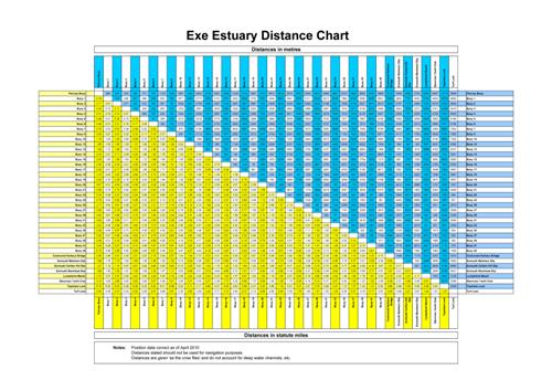
Click here to download the table (PDF file)
Donations
It has taken lots of time and technology to compile this information, and it is free for all users to enjoy.
If you have found it useful, please help contribute to the costs of keeping this site updated by making a small contribution (£2.50) using Paypal. Thank you!
Please Note!
The locations of all the points of interest are not guaranteed. While you can be fairly confident that a bridge or slipway will remain in the same location, the same can't be said for buoys which can be moved any time.
A GPS must never be relied on as the only form of navigation. Ensure you are familiar with the water you are using and that you have alternative means of navigation.
Do not assume that a slipway or launch/recovery location is available for use just because it is shown on the list. Similarly, there is no vehicular access implied for any of these locations!
